
Identifying and Fixing Errors in Drone Surveys: Common Issues and Solutions
Introduction
Drone surveying has revolutionized how we capture and analyze spatial data, offering high precision and efficiency in various applications. However, achieving accurate results can be challenging due to potential errors that can arise during the surveying process. In this blog, we’ll delve into common errors in drone surveys and provide practical solutions to fix them, ensuring reliable and high-quality data.

1. Data Collection Errors
Issue: Data collection errors are often caused by issues with the drone hardware, sensor calibration, improper flight planning or environmental conditions. These errors can lead to inaccurate measurements, misaligned data and incomplete coverage.
Solutions:
- Regular Calibration: Ensure that your drone's sensors and cameras are regularly calibrated according to the manufacturer’s specifications. Calibration should be done before each major survey to maintain accuracy.
- Pre-Flight Checks: Conduct thorough pre-flight checks to ensure all equipment is functioning correctly. This includes checking battery levels, sensor alignment and GPS signal strength.
- Proper Flight Planning: Implement detailed flight planning to ensure sufficient image overlap, correct Ground Control Points (GCPs) placement and appropriate Ground Sampling Distance (GSD). Utilize flight planning software like Drone Mission Ops to map out optimal flight paths, verify the coverage area and account for all required parameters to minimize gaps and inconsistencies in data collection.

- Weather Conditions: Avoid flying in adverse weather conditions such as strong winds, heavy rain or extreme temperatures, as these can affect data quality. Check weather forecasts and plan your flights accordingly.

Download the checklist to ensure the highest accuracy for your drone data collection.
2. Poor Data Processing Techniques
Issue: Errors in data processing can stem from using outdated software, improper settings or inadequate processing techniques. This can lead to inaccuracies in the final output, such as distorted 3D models or misaligned orthophotos.

Solutions:
- Update Software: Use the latest versions of photogrammetry and GIS software to benefit from the latest features and bug fixes.
- Optimize Settings: Configure processing settings based on the type of data and survey objectives. Follow best practices for stitching images, aligning point clouds and creating accurate models.
- Quality Control: Implement rigorous quality control measures throughout the processing phase to identify and correct errors early. This includes cross-referencing results with ground control points and verifying accuracy.
3. Inaccurate Ground Control Points (GCPs)
Issue: Inaccurate or improperly placed Ground Control Points (GCPs) can lead to errors in the georeferencing of your survey data. This can affect the overall accuracy of the final map or model.
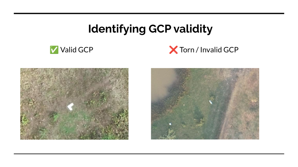
Solutions:
- Precise Placement: Ensure GCPs are accurately placed and measured using high-precision equipment. Verify their coordinates through reliable methods such as GPS surveys.
- Increase GCP Density: Use a higher density of GCPs to improve the accuracy of your georeferencing. Distribute GCPs evenly across the survey area to enhance spatial accuracy.
- Use RTK/PPK Technology: Implement Real-Time Kinematic (RTK) or Post-Processed Kinematic (PPK) systems to enhance GPS accuracy. These systems provide real-time corrections or post-flight adjustments to improve georeferencing.
Conclusion
Identifying and fixing errors in drone surveys is crucial for obtaining accurate and reliable data. By understanding common issues and implementing effective solutions, you can enhance the precision of your drone surveys and ensure high-quality results. Regular maintenance, careful planning and rigorous quality control are key to overcoming these challenges and achieving success in your drone surveying projects.
